
Field attributes provide Surveyors with the ability to include additional data in their Survey pickup of points. With Stringer Topo V26 users can now include additional data (attribute data) with their COGO points and survey strings for review, editing and output from their drawing.
There are a number of ways to add attributes to your drawing:
- Via import of a Trimble JXL or Leica XML file.
- This automatically extracts all the attribute data by attaching data tables with all fields populated, to each point and survey string.
- You can import the COGO Points, add the survey strings at the same time, or use the JXL/XML file to add the attribute data to points and strings already added to your drawing. This provides you the flexibility of using your current data import and reduction processes without losing out on adding attribute data
- Apply Data Tables and assign them to COGO Points and Survey Strings – this can be automated based on the point Codes. You can then easily review, edit and output the attribute data
Once you’ve added Data Tables, you can easily attach them to objects, review the data for each object and manage all objects with a Data Table assigned. We’ve included mass editing tools and highlight for any disallowed inputs, so it’s easy to manage the attributes ahead of sharing them with your customer.
When it comes to outputs, you can:
- Export any Data Table to file or as a Table in the drawing
- Create Point Properties from the attribute data fields, to include in your standard COGO Point outputs
- In Civil 3D, attach the data fields as Property Set data to enable rapid editing in Civil 3D and updating back to the Project Database
- Export GIS files for the points and survey strings, per Data Table
How Attribute Data is Managed
Stringer uses Schemas to provide a relational database consisting of Data Tables, Fields, data types and the relationships between these entities.
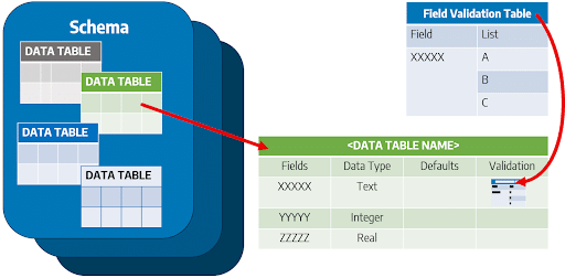
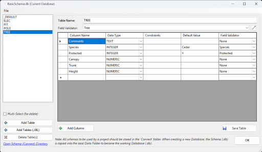
Data Tables within a schema set out the defined Fields (attributes) that can be attached to Objects in the drawing, as well as the allowable inputs for those fields. The Data Table includes the Field name, the Data Type (eg: Text, Integer, Real), a Default value, and an opportunity to set a list of allowable inputs that can be applied (defined by the Field Validator in the software)
What is a Field Validator? Think of a Field Validator as a list which manages allowable inputs for a Field in a Data Table. These are very useful for fields where there are only certain allowable inputs (such as Y and N) because we’ll highlight any fields containing inconsistent inputs, so you can get this right before you share it with your end customer.
Project Databases – Managing Object Data in your Projects
A Schema is considered the ‘blueprint’ of a database which describes how the data may relate to other tables or other data models.
A Schema is added to a Project Database to enable attachment of structured Data Tables to COGO Points and Survey Strings in your drawing.
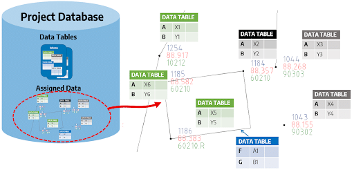
Once a Schema is added to a Project Database, the Data Tables can be edited within that database to manage the Field inputs.
Automating Attribution | Importing JXL/XML Data
Trimble JXL and Leica XML are common outputs supported by modern Trimble and Leica survey equipment. Trimble JXL and Leica XML files contain attribute data, managed via Data Tables, which can be attached directly to COGO Points and Survey Strings in your drawing.
The Import Trimble JXL and Import Leica XML commands deliver two outputs:
- The creation of COGO Points and Survey Strings, using the calculated coordinates contained in the JXL/XML file, and/or
- The addition of extended (attribute) data picked up in the field, applied to Points and Strings created in a drawing. Data Tables are created to support each point contained in the JXL/XML file and data attached for each point
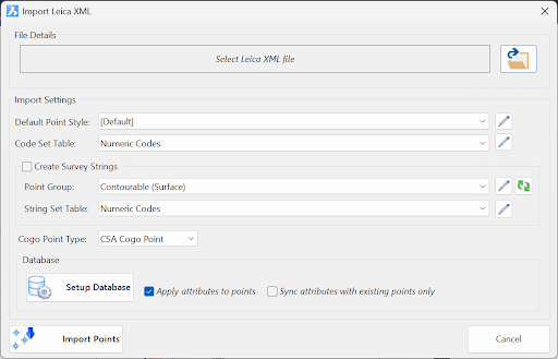
Whilst this command supports the creation of points AND adding the Data Tables, you can instead attach the Data Tables to COGO Points and Survey Strings already in your drawing by ticking on the option ‘Sync attributes with existing points only’.
The JXL/XML import process will create all the Data Tables necessary to support the points picked up in the field, however you can certainly set up a Schema with matching fields and establish allowable field inputs (via the Field Validator) to ensure data compliance.
Adding Attribute Data Tables to Points and Strings
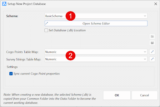
Even if you don’t work with JXL or XML files, you can still set up a Project Database to attach attribute Data Tables to any COGO Points and Survey Strings in your drawing, and then edit and manage the data fields per object.
Adding a Project Database adds a Schema containing Data Tables and allows attribute data to be attached to COGO Points and Survey Strings.
The Attach Data Tables command allows you to select COGO Points and Survey Strings in the drawing and attach one or more Data Tables to them. You can also automate the attachment of Data Tables to points based on the point Code.
Once a Data Table is attached to an object, you can review and edit the data fields.
Reviewing and Editing Attribute Data
There are a number of ways to review and edit attribute data attached to objects.
Edit Object Data
The Edit Object Data command allows you to select a single COGO Point or Survey String and review all Data Tables and data fields attached to that object.

If there are Field Validators set up, you can pick from a drop down list of allowable inputs.
Data Table Viewer
The Data Table Viewer provides a list of all objects with a selected Data Table attached. You can review and edit the data fields for all objects in a single form.

If there are Field Validators set up, you can pick from a drop down list of allowable inputs. If the data field contains an input that is not in the Field Validator list, the cell will be highlighted in red.
You can also use the Data Table Viewer to mass edit data fields for multiple objects.
Civil 3D Property Sets
If you are using Civil 3D, you can attach the Data Tables as Property Set data to the COGO Points and Survey Strings. This allows you to review and edit the data fields using the standard AutoCAD Properties palette.
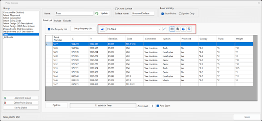
Any changes made to the Property Set data will be updated back to the Project Database.
Outputting Attribute Data
There are a number of ways to output attribute data from your drawing.
Export Data Table
The Export Data Table command allows you to export the data fields for all objects with a selected Data Table attached to a CSV file.

Create Table
The Create Table command allows you to create an AutoCAD Table in the drawing containing the data fields for all objects with a selected Data Table attached.
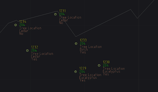
Point Properties
You can create Point Properties from the attribute data fields, to include in your standard COGO Point outputs.
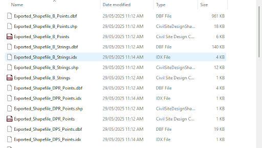
Export GIS
The Export GIS command allows you to export GIS files for the points and survey strings, per Data Table.
Conclusion
Field attributes provide Surveyors with the ability to include additional data in their Survey pickup of points. With Stringer Topo V26 users can now include additional data (attribute data) with their COGO points and survey strings for review, editing and output from their drawing.
If you’d like to learn more about Stringer Topo V26, you can review the Key File Changes or the New Features.
If you’re an existing Stringer Topo user, you can download the latest version from the Customer Portal.
If you’re not an existing Stringer Topo user, you can download a 30-day free trial.